Thunderstorm Front
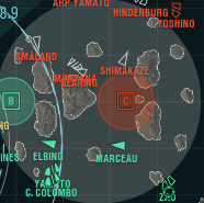
A thunderstorm front or snowstorm is a special event that occurs on some maps. When it occurs, a special indicator appears, indicating when a player is approaching (a black cloud) or in (white cloud) the affected area. On the minimap, the area is shown by a gray circle. Visually, rain and thunder or a blizzard occurs in the game world. A thunderstorm moves from left to right or vice versa, while a snowstorm stays in the center of the map.
When inside a thunderstorm or snowstorm, the following effects occur:
- Detectability range by sea is reduced by 10%.
- If there is an area of foul weather between ships, their detectability is calculated taking into account the visibility modifier. However, this does not affect potential third observers whose line of sight doesn't cross (or run through) the affected area.
- Spotting range is reduced to 30 km.
- The period of when a ship's detectability is increased after firing her guns is reduced from 20 to 7 seconds.
- Maximum dispersion of shells increases by 30%.
Currently, the phenomenon can only occur on the following maps in Tier X battles.
- North (Domination mode)
- Hotspot (Domination mode)
- Islands of Ice (Epicenter mode; snowstorm)
- Greece (Domination mode; 25% chance of a thunderstorm front)
While inside a thunderstorm front or snowstorm, holding the H key (ship status) and hovering the mouse cursor on the cloud icon gives a short description of the effects.
In the training room, the setting to enable a thunderstorm front or snowstorm is called "Local Weather".
Information on the website:
